GeoLocation (GPS) and Self-Tracking
You know what they say: Location Location Location. I posted a reply to yesterday’s Quantified Self article answering what degree of self-tracking I’m already doing. Here’s the rundown:
- Mint for financial tracking and monitoring of budget and spending habits
- Fitbit for tracking activity level, calories burned, distance walked and sleep quality
- (New) MyZeo for detailed sleep tracking. I’m planning on evaluating starting next week.
- WiThings scale to track weight, lean & fat mass
- Detailed workout/fitness logging. I’ve been using a combination of a journal in a semantic wiki and more recently using iFitness on iPhone to log workouts (strength training, cardio, running).
- Time tracking/organization: using a combo of Tracks(GTD), Google Calendar and Reqall
- (New) Using TallyZoo to starting tracking caffeine intake, meditation time, time spent learning/researching and on personal projects
- Dream journal: I haven’t done this much this year, but in the past I’ve kept a detailed record in my semantic wiki
- Daily photos: Wireless webcam at my house that takes a snapshot each minute (for the past 3 years). I can compile fast-motion videos to show the week, month, or even year.
Doing some experiments with MicroGPS is next on my list. I’d like to start keeping a very small GPS on me to track location and coordinates (a little more on the extreme tracking end).
While I’m already doing a decent amount of tracking and analytics, I’ve been lacking location coordinates. In some respects, tracking your location via GPS in real-time can seem very excessive and in fact Orwellian in nature. But, we do have to think about the degree of location tracking that’s already making it’s way into Socia Media. We now have sites like FourSquare, Geocoded tweets on Twitter and now Facebook Places; apps for sharing our location with friends (Loopt), and numerous applications where our GPS coordinates our posted on demand and shared with the rest of the world. I’m less of a fan of sharing this type of info on lots of different sites, especially with commercial organizations. But, I’m very interested in being able to track where I’ve been for personal use and if needed being able to share with close friends and family.
I’ve already done some degree of moderate GPS tracking starting back in 2003 when I received my first decent GPS (Garmin E-Trex Vista). Since that time I’ve faithfully captured many of my hikes, biking trips, and other travels. And, in the last 2 years I’ve started to get into photo geotagging (the process of adding lat/long data to photos and viewing on a map – See this hike for an example). Linking photos to physical locations is useful and can be considered a fairly practical application, but are their benefits to tracking your location ALL the time? This is a deep topic (safety and privacy aside), but what I’m going to do is try this out for at least 30-60 days and see the amount of effort involved, practicality, and see if I can come up with some creative ideas for real-world use. I know that Gordon Bell has made GeoLocaton/GPS tracking a huge part of his MyLifeBits project, and I’d also like some way to complement my own system with location-enhanced information (Ideas to be fleshed out in a future post). Now, the question is, how do I go about realistically tracking my GPS coordinates in real-time virtually all the time?
Real-Time GPS Logging
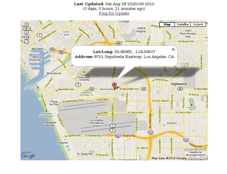
My interest in tracking and finding out where I’m at in real-time actually started a few years ago, way before I was even thinking about a Memex or any degree of self-tracking. Back in 2006, I came across a website called “Where’s Tim“. In a pre-IPhone era, a dedicated techy had managed to hack his phone to post his geocoordinates in real-time every 15 seconds and display his location on his website via Google Maps or Google Earth. I’ve been meaning to do something like this for some time, and now with the plethora of iPhone apps out there offering location-enabled services I figured it was time to dive in. As a quick experiment, I setup Instamapper (GPSTracker int the iPhone Appstore) . This app will post your geocoordinates (lat/long) at defined intervals (say 5-20 seconds) and send the data to the InstaMapper site. You can see your location in real-time and see up to a 30-day history of your GPS tracks.
InstaMapper offers an API so you’re able to download the data and display the most recent or historical track data on your own site. I wrote a quick app that does the following:
- Retrieves the current location from InstaMapper
- Does a reverse geocode (converts the lat/long to an address) to find the street address, city, and zip (Thanks to GeoNames)
- Displays that last time the coordinates where posted (current date/time and offset in days/hours/mins)
- Renders a Google Map and shows my current location with address info
- Provides a Ping request that sends an SMS message to my phone to ask for a recent update
 This is really more of a novelty right now and something that I’ll probably share with family and close friends. It would be great to have real-time logging enabled all the time and download the coordinates directly form InstaMapper. Unfortunately, the real-time aspect comes at a price: battery life. If you run your GPS and this app all the time you can probably expect your battery to last no longer than 5 hours. And, with the iPhone you’ll need to run InstaMapper in the foreground (I have a 3G that can’t multi-task and am currently not Jailbroken with the 4.0.2 IOS). This definitely isn’t practical. So, aside from quickly sharing my location with others and saving tracks for some of my workouts, hikes, and photo ops, I need to find a less battery-intensive option.
GPS Logging With Portable Devices
The advantage of traditional GPS devices (my current device for hiking is the E-Trex Legend HCX) is greater battery life and some more advance location functionality (saving waypoints, tracks, etc.). The downside, of course, is that you have to carry yet another device with you and it tends to be as big or bigger than a cellphone. Lugging around a full-scale GPS like this is not an option. Luckly in the last 2 years there’s been an introduction of a new class of GPS devices that are bordering on micro (weighing ounces, and dimensions like 72.2 (L) X 46.5 (W) X 20 (H) mm). Battery lives are now extending to 32-48 hours without a recharge, logging capabilities are extending to multiple coordinates per second, and the form factor is well….. very tiny. I spend some time researching a few different options today and made a choice. Here were some of the one’s I reviewed:
- SleuthGear iTrail GPS Logger
- Zoombak ZMBK346 Advanced GPS Universal Locator
- Sony GPS-CS3KA GPS Digital Imaging Accessory
- i-Blue 747A+ (Current GPS used by Gordon Bell – mentioned in his book Total Recall)
- Q-1000XT: Qstarz BT-Q1000XT Bluetooth Data Logger GPS Receiver
I ended up going with the Qstarz model due to the overall features, performance, and pricepoint ($109.99 USD – minus a $50 gift certificate I’ve been waiting to use – SCORE!).
 I just placed the order so hopefully I’ll have everything setup by the end of the week. Stay tuned for a follow-up post on my adventures in detailed GPS-tracking!
5 Responses
A related post about FourSquare and getting “Off The Grid”
Check (In) Yo’ Self Before You Wreck Yo’ Self: Why Foursquare Users Check In “Off The Grid”
http://techcrunch.com/2010/08/28/foursquare-off-the-grid/
[…] support – I’ve been tracking GPS coordinates since I purchased my QStarz device in September. I’m thinking of adding a couple Map and […]
Hey! How have you been going with your geo tracking? I’ve started a similar project and I’m sharing and analysing my results.
Hi Simon,
I actually JUST saw your project the other day. It looks incredibly cool! I especially like the concept of the heatmaps, and getting stats on your average day. I just started digging deeper into my geotracking efforts on Mon (Since I posted my article on my progress with my tracking app). My plan is to integrate geotracking and map visualization directly into the UI. To start I was planning on simply adding a schema for storing lat/long values, and created an API to export to various formats and overlay on top of Google maps. I really like your idea on predictive analysis of top locations and where you’re likely to go.
[…] my own personal travel journal and my gradual interest in the Quantified Self movement and using GPS devices to automatically track my location. LA Quantified Self Meetup (10/11) – Location Tracking View more presentations from […]